Hikes In Glacier National Park
There are no shortage of incredible hikes and sights in Glacier Park and you really can’t go wrong with any of them. The park has something for everyone from drivers and beginner hikers to expert back country campers. The most popular areas in the Logan Pass, West, and East Glacier areas will be somewhat crowded but still worth the visit. If you’re more adventurous and looking for some more private hikes, North Glacier is the place to go.
Before heading out to Glacier, make sure you check the Trail Status Reports on the National Park Service’s website. Trails can be closed for many different reasons including Bear activity, Construction, Fish Spawning, or Snow.
West Glacier

Highline Loop
Distance: 11.8 mile loop (shorter if you turn back)
Difficulty: Moderate for length
One of the most iconic hikes in Glacier National Park, the Highline Loop follows the Continental Divide, offering stunning alpine views. The trail is relatively level for a mountain hike, making it accessible for those looking to go the full distance or just a few miles out and back. It passes the historic Granite Park Chalet, one of only two remaining chalets built by the railroad at the turn of the last century.
This is a very popular hike, for good reason, but that does mean the parking lot and trail can be a little crowded.

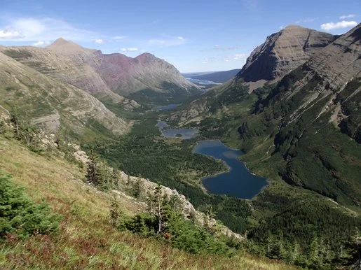
Hidden Lake Overlook
Distance: 2.7 mile roundtrip
Difficulty: Easy to Moderate
Another of the most iconic hikes in Glacier National Park, you’ve probably seen photos of the Hidden Lake Overlook. The view is incredible and there are frequent goat and sheep sightings from the overlook. Most of the hike is on a boardwalk and the overall length is short making this a beginner friendly hike.
This is probably the most popular hike in Glacier due to the ease of access from the Logan Pass parking lot and the relatively short length. Unfortunately, that means this is also probably the most crowded hike too. It is still definitely worth doing if you can find parking.

Siyeh Pass
Distance: 10.3 miles roundtrip
Difficulty: Strenuous
A scenic hike just past Logan Pass, offering spectacular views of Glacier’s rugged terrain. This trail is less crowded than others in the Logan Pass area but still delivers high alpine beauty withy views of glacier-carved valleys and peaks.
Being in the Logan Pass area, you will still need to arrive early to find parking as you’ll be competing for spots with hikers of the Highline and Hidden Lake Overlook trails.

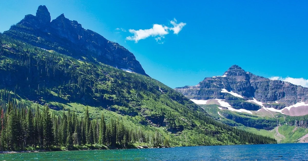
Avalanche Lake
Distance: 4.6 miles roundtrip
Difficulty: Moderate
A scenic, relatively short hike on the west side of Logan Pass, leading to the beautiful Avalanche Lake. This trail is popular for its stunning lake views surrounded by towering peaks.
You will want to go early in the morning or late afternoon to avoid crowds and secure parking as this hike is just inside the West Entrance of the park and popular for those hikers not wanting to take the whole Going to the Sun road up to the pass.
East Glacier

Iceberg Lake
Distance: 9.6 miles roundtrip
Difficulty: Moderate
One of the most spectacular hikes in Glacier, this trail leads through wildflower meadows to a turquoise lake often dotted with small icebergs, even in summer. The trail offers dramatic views of rugged peaks and frequent wildlife sightings.
Trailhead parking is limited so you’ll want to get there early or late to secure a spot.

Grinnell Glacier
Distance: 10.3 miles roundtrip (7.6 miles with boat shuttle)
Difficulty: Strenuous
This trail takes you to the closest accessible glacier in the park, offering incredible views of the glacier and surrounding peaks. Boat rides across two lakes can shorten the hike, but reservations are required.
Book boat reservations early through Glacier Park Boats, as walk-on spots are limited in summer.
Swiftcurrent Pass
Distance: 7.2 miles roundtrip
Difficulty: Easy to moderate
A relatively flat trail in the Many Glacier area, ideal for those seeking an easier hike. The trail passes Redrock Falls and offers stunning views, with the option to stop at Bullhead Lake or continue to Swiftcurrent Pass.
Upper Two Medicine Lake
Distance: 9.4 miles roundtrip
Difficulty: Moderate
A scenic hike in the less-crowded Two Medicine area, leading to the beautiful Upper Two Medicine Lake with waterfalls near the lake. A boat ride can shorten the hike, or you can hike around the lake for a longer adventure.

Pitamakan Pass
Distance: 17.5 miles full loop
Difficulty: Very strenuous
A long, challenging loop offering some of the most incredible views into Glacier’s wildest areas. This is a favorite for adventurous hikers seeking solitude and wilderness through remote backcountry.

Dawson Pass
Distance: 10.2 miles roundtrip
Difficulty: Strenuous
A shorter alternative to the Pitamakan Pass loop, this hike offers similar stunning views into Glacier’s wilderness. A boat ride can reduce the hiking distance.
Book boat rides through Glacier Park Boats. The Two Medicine area is less crowded but still spectacular.

Virginia Falls
Distance: 3.6 miles roundtrip
Difficulty: Moderate
A scenic hike to Virginia Falls, with open views due to a past fire in the area. The falls themselves remain lush and wooded.

St. Mary Falls
Distance: 1.7 miles roundtrip
Difficulty: Easy
A shorter hike in the St. Mary area, leading to the picturesque St. Mary Falls. This trail is easily combined with a boat ride on St. Mary Lake.
Combine with a boat ride on St. Mary Lake for spectacular views of Logan Pass and the Continental Divide.
North Glacier

Logging Lake
Distance: 14.8 miles roundtrip
Difficulty: Strenuous
A trail in the remote North Fork area, leading to Logging Lake. A past fire has opened up views, but the best scenery is at the lake itself.
Watch out for bugs in the early season (June) or if it’s been a rainy summer.
Quartz Lake Loop
Distance: 12.8 miles full loop or 6 miles out and back
Difficulty: Moderate to strenuous
A beautiful loop trail starting from Bowman Lake, with an option to shorten by hiking to Quartz Lake and returning. The trail offers beautiful lake and forest views.

Upper Kintla Lake
Distance: 5.5 miles roundtrip
Difficulty: Moderate
A remote hike in the North Fork area, accessible by paddling across Kintla Lake to cut off significant mileage. The trail leads to the scenic Upper Kintla Lake.
The North Fork area is a 1.5-hour drive on mixed dirt and pavement roads. Rent canoes or kayaks through North Fork Recreation. Visit the Polebridge Mercantile for fresh baked goods.